A field is a rule associating a value to each location in the 3D space. These values are usually numbers (scalars). A scalar field, defined by a mathematical function F, returns a numerical value F (x, y, z) at each point  P = (x, y, z). The values throughout a field function are not always scalar. Sometimes, instead, they are vectors, yielding a vector field. Weather reports can help us to understand fields. For example, the temperature and humidity at various locations throughout the atmosphere demonstrate scalar fields, and wind velocity a vector field.

Fields in nTop

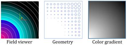
It may be helpful to think of fields as “gradients for geometry”. Just as gradients allow you to control the variation of color across an image, fields in nTop give you precise control over spatial variations of shape. In the 2D representation of a signed-distance field, ramped geometry, and a color gradient below, you can see that a field can be used to radially control geometry (in this case, the pattern and diameters of holes on a plate), just as a radial gradient is used to control the grey level on the right.
In nTop, you can use fields extensively to control spatial variations of different design variables such as lattice beam or wall thicknesses, fillet radii, and material properties. To create a variation, you can use any parameter with the “WiFi” symbol next to it to drive a scalar field instead of a fixed number.